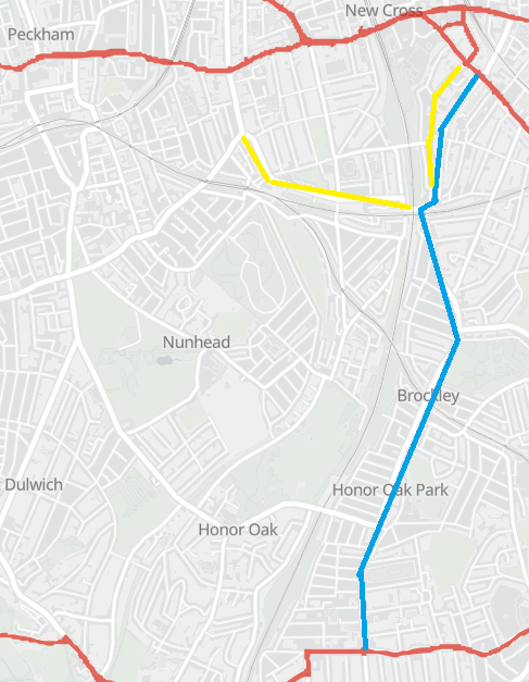
Brockley Road safety scheme begins but more roads ask to join
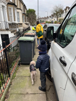
Pavement widening at the Harefield Road / Coulgate Street junction has started, while residents from Shardeloes, Drakefell and Gellatly roads campaign to be included in the programme.
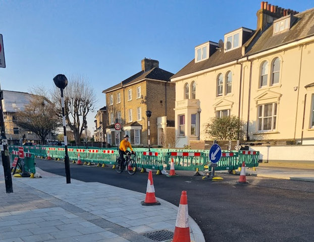
Construction is underway on the intersection between Brockley Road, Harefield Road and Coulgate Street, widening pavements and painting a zebra crossing, as part of a larger effort to improve safety along Brockley Road.
Lewisham council's proposed road safety scheme will cover improvements along the stretch of the B218 from the Brockley Cross/Endwell Road junction to the A205 South Circular.
But two neighbourhood groups have launched petitions, lobbying for the scheme to go further and asking the council to extend improvements to their nearby roads.
The work at the junction with Harefield Road and Coulgate Street has begun ahead of the public consultation on the scheme planned for June/July 2026.
The intersection is a major crossing point for those trying to reach Brockley Station or the shops on the pedestrianised section of Coulgate Street.
Pedestrians previously had to use an island in the middle of two lanes of fast moving traffic. The new design aims to encourage cars to reduce their speed and make it safer, regardless of whether travelling on foot or with wheels.
The two lanes of traffic have been brought closer together by the pavement widening, which stretches south to Harcourt Road on the west side of the road.

A spokesperson for Lewisham council said: “Works to the Brockley Road/Harefield Road/Coulgate Road junction are a ‘quick win’ intervention facilitated by funding from Transport for London (TfL).
"It is designed to address longstanding issues raised by residents, focused on creating a safer intersection for pedestrians and cyclists by slowing down traffic and providing more segregation. It will also eliminate a known fly-tipping hotspot.”
Though the programme is funded by TfL, the road is owned by Lewisham council. TfL owns London's ‘A’ roads, which are 5% of the capital's roads and carry 30% of its traffic.
In their 2025 results, Healthy Streets Scorecard said: “Within Inner London, Lewisham remains last out of 14, but with an increasing gap underscoring the urgent need to match the pace set by neighbouring boroughs.”
The scorecard looks at everything from amount of cycle lanes, 20mph speed limits, share of active travel and importantly, Vision Zero.
Vision Zero is the stated goal of eliminating all deaths and severe injuries from traffic accidents. 81% of those killed or seriously injured on London's roads are people walking, cycling or motorcycling.
The council says that interventions like the Harefield Road/Coulgate Street pavement widening are intended to reduce the risk of collisions and create an "easier environment" for walking, wheeling, and cycling.
Support independent community news. Subscribe or leave a tip.
A dangerous "corridor"
When conducting early public engagement on the scheme, the council said:
“The Brockley Cross to Brockley Rise corridor has been identified as one of the most collision-prone areas in Lewisham.
This project aims to significantly reduce collisions - particularly those resulting in death or serious injury (KSIs), to better protect road users, in line with the Mayor of London’s Vision Zero target of eliminating KSIs by 2041.”
Sections of Brockley Road relate to different high priority corridors identified in the council's Active Travel Strategy.
Four of those corridors pass through or arrive at Brockley Station, while Harefield Road junction sits near the corridor that is intended to stretch from Surrey Quays to Crofton Park, which diverges down Foxberry Road.
Stretches of cycle route 66 which has seen some improvements recently run parallel to Brockley Road, from Foxberry Road to the south circular, but then joins Brockley Road between Holdenby Road and Beecroft Road in Crofton Park.
Although there has been pavement widening here, cyclists are directed onto the narrowed Brockley road.
Brockley Cross is the complicated and dangerous double junction north of Brockley station. Six different main roads carrying heavy traffic meet with multiple mini-roundabouts, causing long queues and congestion, with further roads merging in a few metres west.
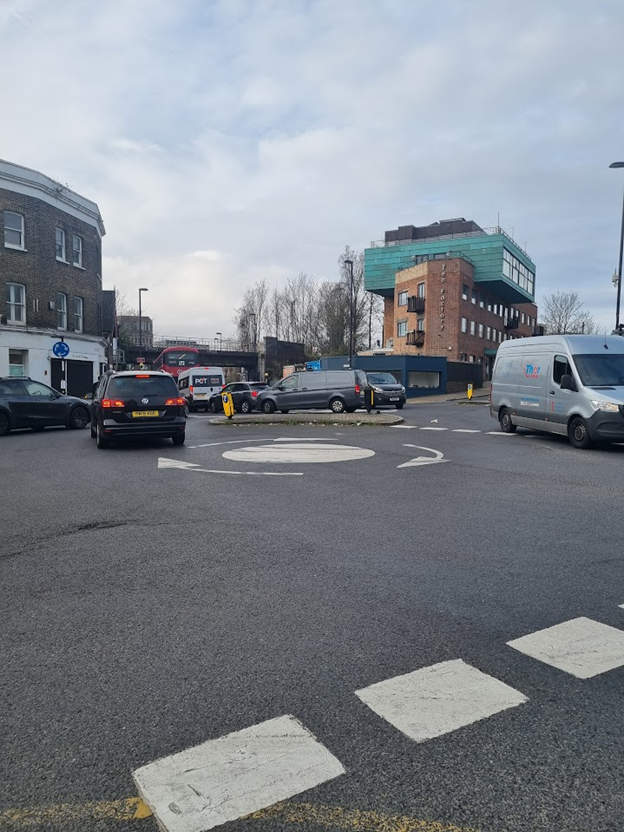
The council spokesperson said: “A safety review of Brockley Cross, for which we anticipate starting local engagement in early summer (2026), will also give an opportunity for residents to raise their concerns on the southern entry to Shardeloes Road.”
The scheme incorporates the B218 at Malpas Road, but Shardeloes Road, which also meets the Brockley Cross junction from the north, is not currently included.
Residents collecting speeding data
Residents of Shardeloes Road have launched a petition, calling for improved safety features.
Campaigners met with Louise Krupski, Lewisham councillor and cabinet member for environment, transport and climate action on 17 March, alongside council officers from the highway team, to raise their concerns.
However, they reported that officers informed them that their road was not eligible for inclusion in the Brockley corridor scheme and other sources of funding would need to be sought.
Campaigner Henry Buswell said: “We regularly see serious speeding, often by heavy vehicles, which make up an unusually high proportion of the vehicles on the road. We see frequent accidents from our doorstep.
"I've collected seven months of traffic data from an AI-powered monitoring system, which supports many of these concerns.”
Determined to make the case to the council for improvements, he purchased a Telraam, which collects data during daytime hours. He says that his data shows an average of 72 cars a day were driving at double the 20mph speed limit.
“It is a matter of grave concern that nearly 16,000 cars were recorded at double the legal speed limit. According to TfL’s Vision Zero research, the survival rate for a pedestrian hit at 40 mph is nearly zero.
"If accounting for both heavy vehicles and night time traffic, this number would be far higher.”
The group calls for the street to be redesigned so that the speed limit is "self enforcing", arguing that on 20 mph streets "drivers should understand the speed limit from the layout, not just from a sign.”
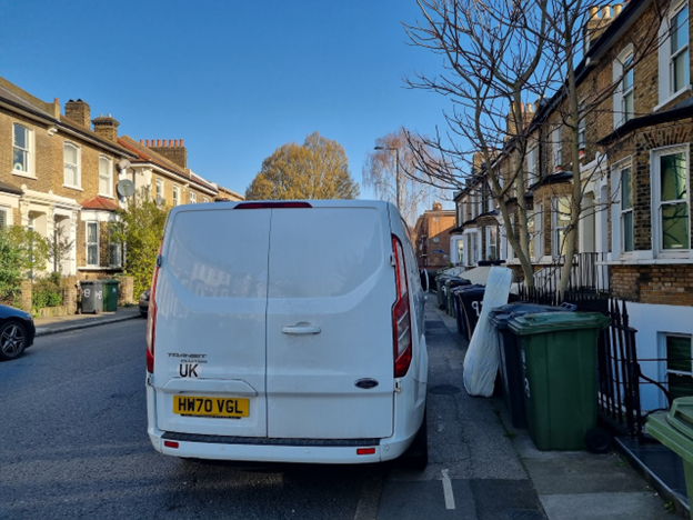
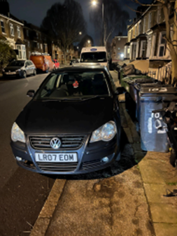
Pavement parking in Shardeloes Road, with little room to squeeze between bins and cars. Images: Tomliyn Rupert, Henry Buswell.
Another branch from Brockley Cross junction is the B2141 Drakefell Road, which becomes Gellatly Road going north towards Lausanne Road.
Residents group Drakefell and Gellatly United say they have been campaigning for road safety improvements "since the 1980s".
Their latest petition closed at the end of February with over 900 signatures, and asks for similar measures of safe crossings, buildouts to protect parked cars and an end to pavement parking.
Is pavement parking legal?
Living Streets point out that the law on pavement parking varies around the country, and enforcement is treated differently in different areas.
Although the organisation is enthusiastic about London's measures, in fact this varies from borough to borough and street to street.
Lewisham council identifies roads where footway (pavement) parking is permitted. For Drakefell Road and Gellatly Road, pavement parking is "partially permitted".
For Shardeloes Road, pavement parking is "partially permitted" on the odd-number side between no.s 91 - 115.
But enforcement of pavement parking is a further question, although in theory drivers could receive a Penalty Charge Notice (PCN).
Would the Sustainable Streets programme have helped?
Shardeloes Road, Drakefell Road and Gellatly Road were all included in Lewisham council's Sustainable Streets Programme consultation for Brockley and surrounding areas.
The programme ran across the borough from 2023 - 2025 and follow-up consultation is still taking place.
The scheme aimed to address parking issues with controlled parking zones (CPZs) and then use the funds raised from drivers' parking permits to fund improvements to their own road - including safer crossings, street trees, cycle hangers and electric vehicle charging points.
These measures, along with the new parking bays, would form part of an improved road design to reduce vehicle speeds, and make roads safer for pedestrians and cyclists.
In the Brockley area, the programme also proposed removing the current pavement parking permissions.
The programme met hostility from the majority of drivers across the borough and several organised campaigns opposing the CPZ. In some areas, supporters of the scheme were intimidated by opponents.
Non-drivers and cyclists were underrepresented in responses.
In the campaigners' roads, the majority of responses opposed the CPZ:
- Drakefell Road 58 opposed, 50 in favour
- Gellatly Road 23 opposed, 20 in favour
- Shardeloes 2 were opposed and 7 in favour
The respondents across the three roads strongly supported safer crossings.
Unfortunately, all measures, except extending double yellow lines, were to be paid from the parking permits, so the relatively small number of opponents tipped the balance, preventing these measures.
Majority support for the scheme would have been a way to bring the improvements forward.
In a difficult funding environment, campaigners may face difficulty seeing their visions for safer roads come to life if consultations continue to be led by motorists.
As campaigner Henry Buswell said of the council team’s visit to Shardeloes Road, “Somewhat unexpectedly, discussion of the road layout shifted towards the possible introduction of a CPZ. Apparently the two are somehow inextricably linked.”
Additional reporting by Dorothy Stein with references Mark Morris.
Sign-up for our free weekly newsletter - Salamander News in your inbox